


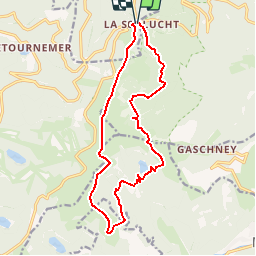
Vosges - Sentier des roches
© OpenStreetMap contributors


--
Difficulty : Medium


Length
15.2 km
Max alt
1310 m
Uphill gradient
896 m
Km-Effort
27 km
Min alt
922 m
Downhill gradient
903 m
Boucle
Yes
Creation date :
2014-12-10 00:00:00.0
Updated on :
2014-12-10 00:00:00.0
--
Difficulty : Medium
FREE GPS app for hiking
 SityTrail
IGN / Geographical institutes
SityTrail Plus
The world is yours!
About
Trail Walking of 15.2 km to be discovered at Grand Est, Vosges, Le Valtin. This trail is proposed by aurianlecomte@hotmail.com.
Description
Sentier des roches - col entre les honeck - lac de Schiessrothried - Kastelberg - le honeck - Col de Falimont - col de la Schlucht
Physique (/10) : 6
Technique (/10) : 8
Positioning
Country:
France
Region :
Grand Est
Department/Province :
Vosges
Municipality :
Le Valtin
Location:
Unknown
Start:(Dec)
Start:(UTM)
352683 ; 5325255 (32U) N.
Comments
très belle, très variée, passages difficiles à ne pas privilégier avec des enfants de moins de 10/12 ans
Belle ballade. Difficile pour randonneur en bonne forme physique. Passages de pierriers délicats après le lac du Schiesrothried. Distance sous-évaluée : 23 km au GPS. A ne faire que par grand beau temps. Repas sympathique à la ferme-auberge du Schiesroth.